Data and code
Open resources from our group
We believe in open science, so we publish most of our code and data openly. We do that mostly through our Github account.
Please see below for a list of resources and projects, especially lab-grown datasets, which we are happy to make public. On this page, we also include open outputs led by collaborators, in which we were involved.
On a related note, you may be interested in our comprehensive survey on open-source software, led by our Winston Yap, published as a review paper in Computers, Environment and Urban Systems.
In general, all resources are released under a liberal licence, enabling unrestricted use as long as you properly attribute them. If you use the code and/or the data for presentations and publications, we kindly ask you to cite the related paper(s) and credit our work. We have provided guidelines to do so in each resource.
The usual disclaimer: while a great deal of effort and care has been put into each project, they are not free of errors, and we cannot be held responsible for the use of code and/or data and any issues that may arise. All code and data are provided as is.
Feel free to contact us for more information, report bugs and errors, or simply to inform us what are you using the data for. We would be pleased to learn how others are using our work. If you are interested in collaborating with us, please get in touch with the lead developer of each resource listed below.
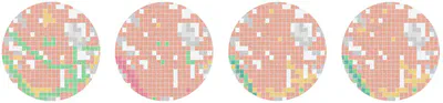
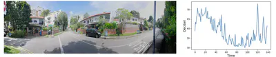
Vision2Slope

| Short description: | An integrated pipeline for two-level road slope analysis from single panoramic street view images. |
| Lead developer: | Yang Chen |
| Further reading: | Please read the paper published in IJGIS |
| Repository: | Github repo |
| Citation: | Click to view the BibTeX entry@article{2026_ijgis_vision2slope, author = {Chen, Yang and Fan, Zicheng and Li, Hao and Zhao, Wufan and Yang, Xin and Tang, Guoan and Biljecki, Filip}, doi = {10.1080/13658816.2026.2656269}, journal = {International Journal of Geographical Information Science}, pages = {1–45}, title = {Vision2Slope: estimating urban road slopes with street view imagery}, year = {2026} } |
VoxCity
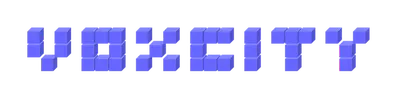
| Short description: | A one-stop Python package for open geospatial data integration, 3D city model generation, and urban environment simulation. |
| Lead developer: | Kunihiko Fujiwara |
| Further reading: | Please read the paper published in CEUS |
| Repository: | Github repo |
| Citation: | Click to view the BibTeX entry@article{2026_ceus_voxcity, author = {Fujiwara, Kunihiko and Tsurumi, Ryuta and Kiyono, Tomoki and Fan, Zicheng and Liang, Xiucheng and Lei, Binyu and Yap, Winston and Ito, Koichi and Biljecki, Filip}, doi = {10.1016/j.compenvurbsys.2025.102366}, journal = {Computers, Environment and Urban Systems}, pages = {102366}, title = {VoxCity: A seamless framework for open geospatial data integration, grid-based semantic 3D city model generation, and urban environment simulation}, volume = {123}, year = {2026} } |
OpenFACADES

| Short description: | An open framework for architectural caption and attribute data enrichment via street view imagery. |
| Lead developer: | Xiucheng Liang |
| Further reading: | Please read the paper published in ISPRS J |
| Repository: | Github repo |
| Citation: | Click to view the BibTeX entry@article{2025_ijprs_openfacades, author = {Liang, Xiucheng and Xie, Jinheng and Zhao, Tianhong and Stouffs, Rudi and Biljecki, Filip}, doi = {10.1016/j.isprsjprs.2025.10.014}, journal = {ISPRS Journal of Photogrammetry and Remote Sensing}, pages = {918–942}, title = {OpenFACADES: An open framework for architectural caption and attribute data enrichment via street view imagery}, volume = {230}, year = {2025} } |
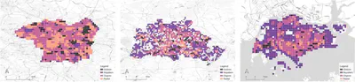
SPECS
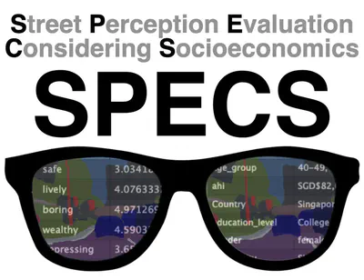
| Short description: | A massive urban visual perception survey including 1000 people globally, with their demographic and personality data. |
| Lead developer: | Matias Quintana |
| Further reading: | Please read the paper published in Nature Cities |
| Repository: | Github repo |
| Citation: | Click to view the BibTeX entry@article{2025_natcities_specs, author = {Quintana, Matias and Gu, Youlong and Liang, Xiucheng and Hou, Yujun and Ito, Koichi and Zhu, Yihan and Abdelrahman, Mahmoud and Biljecki, Filip}, doi = {10.1038/s44284-025-00330-x}, journal = {Nature Cities}, number = {11}, pages = {1092–1106}, title = {Global urban visual perception varies across demographics and personalities}, volume = {2}, year = {2025} } |
SP-Survey

| Short description: | A simple and powerful platform for conducting streetscape perception surveys with image-based questions. |
| Lead developer: | Sijie Yang |
| Further reading: | Please read the paper published in BAE |
| Code: | Github repo |
| Citation: | Click to view the BibTeX entry@article{2025_bae_thermal, author = {Yang, Sijie and Chong, Adrian and Liu, Pengyuan and Biljecki, Filip}, doi = {10.1016/j.buildenv.2025.112569}, journal = {Building and Environment}, pages = {112569}, title = {Thermal comfort in sight: Thermal affordance and its visual assessment for sustainable streetscape design}, volume = {271}, year = {2025} } |
ZenSVI

| Short description: | An open-source Python package to streamline your projects relying on Street View Imagery (SVI), from their download to analysis. |
| Lead developer: | Koichi Ito |
| Further reading: | Please read the paper published in CEUS |
| Code: | Github repo |
| Documentation: | Website |
| Citation: | Click to view the BibTeX entry@article{2025_ceus_zensvi, author = {Ito, Koichi and Zhu, Yihan and Abdelrahman, Mahmoud and Liang, Xiucheng and Fan, Zicheng and Hou, Yujun and Zhao, Tianhong and Ma, Rui and Fujiwara, Kunihiko and Ouyang, Jiani and Quintana, Matias and Biljecki, Filip}, doi = {10.1016/j.compenvurbsys.2025.102283}, journal = {Computers, Environment and Urban Systems}, pages = {102283}, title = {ZenSVI: An open-source software for the integrated acquisition, processing and analysis of street view imagery towards scalable urban science}, volume = {119}, year = {2025} } |
Nighttime Street View Imagery
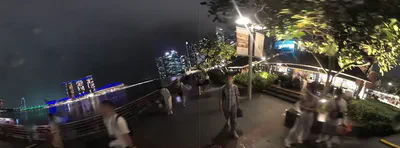
| Short description: | A large set of images collected during nighttime to support our explorations on this latent kind of urban visual data. |
| Lead developer: | Zicheng Fan |
| Further reading: | Please read the paper published in Sustainable Cities and Society |
| Download: | Github repo (also uploaded on Mapillary) |
| Main data source(s): | Own data collection |
| Coverage: | Singapore |
| Citation: | Click to view the BibTeX entry@article{2024_scs_nightSVI, author = {Fan, Zicheng and Biljecki, Filip}, doi = {10.1016/j.scs.2024.105862}, journal = {Sustainable Cities and Society}, pages = {105862}, title = {Nighttime Street View Imagery: A new perspective for sensing urban lighting landscape}, volume = {116}, year = {2024} } |
TreeShadeMapper

| Short description: | A panorama-based technique to estimate sky view factor and solar irradiance considering transmittance of tree canopies |
| Lead developer: | Kunihiko Fujiwara |
| Further reading: | Please read the paper published in BAE |
| Code: | Github repo |
| Citation: | Click to view the BibTeX entry@article{2024_bae_svf, author = {Fujiwara, Kunihiko and Ito, Koichi and Ignatius, Marcel and Biljecki, Filip}, doi = {10.1016/j.buildenv.2024.112071}, journal = {Building and Environment}, pages = {112071}, title = {A panorama-based technique to estimate sky view factor and solar irradiance considering transmittance of tree canopies}, volume = {266}, year = {2024} } |
Microclimate Vision

| Short description: | Multimodal prediction of climatic parameters using street-level and satellite imagery |
| Lead developer: | Kunihiko Fujiwara |
| Further reading: | Please read the paper published in SCS |
| Code: | Github repo |
| Citation: | Click to view the BibTeX entry@article{2024_scs_microclimate_vision, author = {Fujiwara, Kunihiko and Khomiakov, Maxim and Yap, Winston and Ignatius, Marcel and Biljecki, Filip}, doi = {10.1016/j.scs.2024.105733}, journal = {Sustainable Cities and Society}, pages = {105733}, title = {Microclimate Vision: Multimodal prediction of climatic parameters using street-level and satellite imagery}, volume = {114}, year = {2024} } |
Global Streetscapes
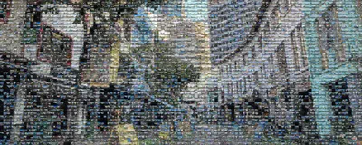
| Short description: | A comprehensive dataset of 10 million street-level images across 688 cities for urban science and analytics. |
| Lead developer: | Yujun Hou |
| Further reading: | Please read the paper published in the ISPRS Journal of Photogrammetry and Remote Sensing |
| Website: | Website |
| Download: | Github repo |
| Main data source(s): | Mapillary, KartaView, OpenStreetMap, GADM, … and manual labelling |
| Coverage: | 688 cities around the world |
| Citation: | Click to view the BibTeX entry@article{2024_global_streetscapes, author = {Hou, Yujun and Quintana, Matias and Khomiakov, Maxim and Yap, Winston and Ouyang, Jiani and Ito, Koichi and Wang, Zeyu and Zhao, Tianhong and Biljecki, Filip}, doi = {10.1016/j.isprsjprs.2024.06.023}, journal = {ISPRS Journal of Photogrammetry and Remote Sensing}, pages = {216-238}, title = {Global Streetscapes – A comprehensive dataset of 10 million street-level images across 688 cities for urban science and analytics}, volume = {215}, year = {2024} } |
Urbanity

| Short description: | A network-based python package to understand and model urban complexity |
| Lead developer: | Winston Yap |
| Further reading: | Please read the paper published in npj Urban Sustainability |
| Code: | Github repo |
| Data: | Figshare |
| Main data source(s): | OpenStreetMap, Mapillary, etc. |
| Citation: | Click to view the BibTeX entry@article{2023_npjus_urbanity, author = {Yap, Winston and Stouffs, Rudi and Biljecki, Filip}, doi = {10.1038/s42949-023-00125-w}, journal = {npj Urban Sustainability}, title = {{Urbanity: automated modelling and analysis of multidimensional networks in cities}}, volume = {3}, issue = {45}, year = {2023} } |
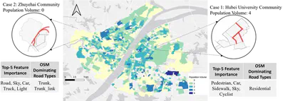
Predicting building characteristics using graph neural networks and street-level contexts

| Short description: | This repo is for our paper “Predicting building characteristics using graph neural networks and street-level contexts” |
| Lead developer: | Binyu Lei |
| Further reading: | Please read the paper published in CEUS |
| Code: | Github repo |
| Citation: | Click to view the BibTeX entry@article{2024_ceus_gnn_building, author = {Lei, Binyu and Liu, Pengyuan and Milojevic-Dupont, Nikola and Biljecki, Filip}, doi = {10.1016/j.compenvurbsys.2024.102129}, journal = {Computers, Environment and Urban Systems}, pages = {102129}, title = {Predicting building characteristics at urban scale using graph neural networks and street-level context}, volume = {111}, year = {2024} } |
Explainable spatially explicit geospatial artificial intelligence in urban analytics
| Short description: | This repo is for our paper “Explainable spatially explicit geospatial artificial intelligence in urban analytics” |
| Lead developer: | Pengyuan Liu |
| Further reading: | Please read the paper published in EPB |
| Code: | Github repo |
| Citation: | Click to view the BibTeX entry@article{2024_epb_xai, author = {Liu, Pengyuan and Yan, Zhang and Biljecki, Filip}, doi = {10.1177/23998083231204689}, journal = {Environment and Planning B: Urban Analytics and City Science}, pages = {1104–1123}, title = {{Explainable spatially explicit geospatial artificial intelligence in urban analytics}}, volume = {51}, issue = {5}, year = {2024} } |
Computer Vision and Graph Models to Predict Outdoor Comfort
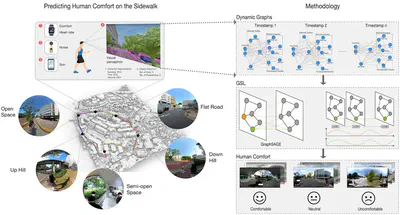
| Short description: | This repo is for our paper “Towards Human-centric Digital Twins: Leveraging Computer Vision and Graph Models to Predict Outdoor Comfort” |
| Lead developer: | Pengyuan Liu |
| Further reading: | Please read the paper published in SCS |
| Code: | Github repo |
| Main data source(s): | Own field survey |
| Citation: | Click to view the BibTeX entry@article{2023_scs_human_dt, author = {Liu, Pengyuan and Zhao, Tianhong and Luo, Junjie and Lei, Binyu and Frei, Mario and Miller, Clayton and Biljecki, Filip}, doi = {10.1016/j.scs.2023.104480}, journal = {Sustainable Cities and Society}, pages = {104480}, title = {{Towards Human-centric Digital Twins: Leveraging Computer Vision and Graph Models to Predict Outdoor Comfort}}, volume = {93}, year = {2023} } |
InstantCITY - Synthesising morphologically accurate geospatial data for urban form analysis, transfer, and quality control
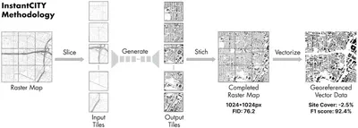
| Short description: | Generating vectorised building footprint data from street networks using Generative Adversarial Networks |
| Lead developer: | Abraham Noah Wu |
| Further reading: | Please read the paper published in IJPRS |
| Code: | Github repo |
| Main data source(s): | OpenStreetMap |
| Citation: | Click to view the BibTeX entry@article{2023_ijprs_instantcity, author = {Wu, Abraham Noah and Biljecki, Filip}, doi = {10.1016/j.isprsjprs.2022.11.005}, journal = {ISPRS Journal of Photogrammetry and Remote Sensing}, pages = {90-104}, title = {InstantCITY: Synthesising morphologically accurate geospatial data for urban form analysis, transfer, and quality control}, volume = {195}, year = {2023} } |
Water View Imagery

| Short description: | On-water perspective imagery dataset for semantic segmentation of waterscapes. |
| Lead developer: | Junjie Luo |
| Further reading: | Please read the paper published in Ecological Indicators |
| Download: | Github repo |
| Main data source(s): | Mapillary and manual labelling |
| Coverage: | Eight cities: Amsterdam, Bangkok, Chicago, Istanbul, Japan, London, Paris, and Venice |
| Citation: | Click to view the BibTeX entry@article{2022_ei_water_view_imagery, author = {Luo, Junjie and Zhao, Tianhong and Cao, Lei and Biljecki, Filip}, doi = {10.1016/j.ecolind.2022.109615}, journal = {Ecological Indicators}, pages = {109615}, title = {Water View Imagery: Perception and evaluation of urban waterscapes worldwide}, volume = {145}, year = {2022} } |
Global Urban Road Network Patterns
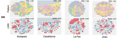
| Short description: | Deep learning-based analysis of the urban morphology around the world |
| Lead developer: | Wangyang Chen |
| Further reading: | Please read the paper published in Landscape and Urban Planning |
| Code: | Github repo |
| Main data source(s): | OpenStreetMap |
| Coverage: | 144 cities |
| Citation: | Click to view the BibTeX entry@article{2024_land_urn, author = {Chen, Wangyang and Huang, Huiming and Liao, Shunyi and Gao, Feng and Biljecki, Filip}, doi = {10.1016/j.landurbplan.2023.104901}, journal = {Landscape and Urban Planning}, title = {{Global urban road network patterns: Unveiling multiscale planning paradigms of 144 cities with a novel deep learning approach}}, volume = {241}, pages = {104901}, year = {2024} } |
SVIQC – Street View Imagery Quality Checker
| Short description: | A toolkit to examine the quality of street view imagery |
| Lead developer: | Yujun Hou |
| Further reading: | Please read the paper published in JAG |
| Code: | Github repo |
| Main data source(s): | Mapillary |
| Citation: | Click to view the BibTeX entry@article{2022_jag_svi_quality, year = {2022}, title = {{A comprehensive framework for evaluating the quality of street view imagery}}, author = {Hou, Yujun and Biljecki, Filip}, journal = {International Journal of Applied Earth Observation and Geoinformation}, doi = {10.1016/j.jag.2022.103094}, pages = {103094}, volume = {115} } |
Visual soundscapes
| Short description: | Predicting the urban soundscape from street view imagery |
| Lead developer: | Tianhong Zhao |
| Further reading: | Please read the paper published in CEUS |
| Code: | Github repo |
| Citation: | Click to view the BibTeX entry@article{2023_ceus_soundscapes, author = {Zhao, Tianhong and Liang, Xiucheng and Tu, Wei and Huang, Zhengdong and Biljecki, Filip}, doi = {10.1016/j.compenvurbsys.2022.101915}, journal = {Computers, Environment and Urban Systems}, pages = {101915}, title = {Sensing urban soundscapes from street view imagery}, volume = {99}, year = {2023} } |
GBMI – Global Building Morphology Indicators

| Short description: | Billions of built form metrics of selected urban areas around the world, together with a database solution to compute them |
| Lead developer: | Yoong Shin Chow |
| Formats | CSV, Shapefile, Geopackage, GeoTIFF |
| Further reading: | Please read more at our website or in the paper published in Computers, Environment and Urban Systems |
| Download: | Project website |
| Code: | The code used to generate the dataset is available in the Github repo |
| Main data source(s): | OpenStreetMap, GADM |
| Coverage: | Dozens of urban areas around the world |
| Citation: | Click to view the BibTeX entry@article{2022_ceus_gbmi, author = {Biljecki, Filip and Chow, Yoong Shin}, doi = {10.1016/j.compenvurbsys.2022.101809}, journal = {Computers, Environment and Urban Systems}, pages = {101809}, title = {Global Building Morphology Indicators}, volume = {95}, year = {2022} } |
Roofpedia – solar and green roofs around the world
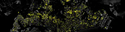
| Short description: | Locations of buildings that have installed photovoltaics or greenery on their rooftops |
| Lead developer: | Abraham Noah Wu |
| Formats | GeoJSON |
| Further reading: | Please read more at our website or in the paper published in Landscape and Urban Planning |
| Download: | Github repo |
| Code: | The code used to generate the dataset is available in the same Github repo |
| Main data source(s): | Various satellite imagery, OpenStreetMap. All open data |
| Coverage: | 17 cities around the world |
| Citation: | Click to view the BibTeX entry@article{roofpedia, author = {Abraham Noah Wu and Filip Biljecki}, doi = {10.1016/j.landurbplan.2021.104167}, journal = {Landscape and Urban Planning}, pages = {104167}, title = {Roofpedia: Automatic mapping of green and solar roofs for an open roofscape registry and evaluation of urban sustainability}, url = {https://doi.org/10.1016/j.landurbplan.2021.104167}, volume = {214}, year = 2021 } |
Semantic Riverscapes
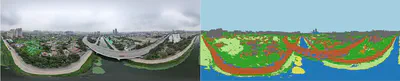
| Short description: | A semantically annotated UAV oblique image dataset covering an urban river landscape |
| Lead developer: | Junjie Luo |
| Further reading: | Please read the paper published in Landscape and Urban Planning |
| Download: | Github repo |
| Main data source(s): | Own data collection (UAV) and manual labelling |
| Coverage: | Tianjin (China) |
| Citation: | Click to view the BibTeX entry@article{2022_land_semantic_riverscapes, year = {2022}, title = {{Semantic Riverscapes: Perception and evaluation of linear landscapes from oblique imagery using computer vision}}, author = {Luo, Junjie and Zhao, Tianhong, and Cao, Lei and Biljecki, Filip}, journal = {Landscape and Urban Planning}, doi = {10.1016/j.landurbplan.2022.104569}, pages = {104569}, volume = {228} } |
Classification of Urban Morphology with Deep Learning
| Short description: | Software to generate diagrams of the urban form at the city-scale and classify them using deep learning |
| Lead developer: | Wangyang Chen |
| Further reading: | Please read more in the paper published in Computers, Environment and Urban Systems |
| Code: | Github repo |
| Citation: | Click to view the BibTeX entry@article{2021_ceus_dl_morphology, author = {Wangyang Chen and Abraham Noah Wu and Filip Biljecki}, doi = {10.1016/j.compenvurbsys.2021.101706}, journal = {Computers, Environment and Urban Systems}, pages = {101706}, title = {Classification of Urban Morphology with Deep Learning: Application on Urban Vitality}, url = {https://doi.org/10.1016/j.compenvurbsys.2021.101706}, volume = {90}, year = 2021 } |
GANmapper: geographical data translation
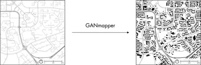
| Short description: | A building footprint generator using Generative Adversarial Networks from sparse data such as street networks |
| Lead developer: | Abraham Noah Wu |
| Further reading: | Please read more in the paper published in the International Journal of Geographical Information Science |
| Code: | Github repo |
| Citation: | Click to view the BibTeX entry@article{2022_ijgis_ganmapper, year = {2022}, author = {Wu, Abraham Noah and Biljecki, Filip}, title = {{GANmapper: geographical data translation}}, journal = {International Journal of Geographical Information Science}, doi = {10.1080/13658816.2022.2041643}, volume = {36}, issue = {7}, pages = {1394-1422} } |
3D dataset of all public housing (HDB) buildings in Singapore
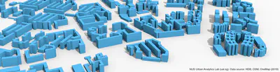
| Short description: | About 12k semantically rich 3D buildings in Singapore in CityJSON and OBJ |
| Lead developer: | Filip Biljecki |
| Formats | CityJSON, OBJ |
| Further reading: | Please read more here in our blog post or in the paper published at 3D GeoInfo |
| Download: | Github repo |
| Code: | The code used to generate the dataset is available in a separate Github repo |
| Main data source(s): | HDB, OpenStreetMap, OneMap. All open data |
| Coverage: | Singapore |
| Citation: | Click to view the BibTeX entry@article{2020_3dgeoinfo_3d_asean, author = {Biljecki, F.}, doi = {10.5194/isprs-annals-vi-4-w1-2020-37-2020}, journal = {ISPRS Annals of Photogrammetry, Remote Sensing and Spatial Information Sciences}, pages = {37–44}, title = {Exploration of open data in Southeast Asia to generate 3D building models}, volume = {VI-4/W1-2020}, year = {2020} } |
With our friendly collaborators
ProbGLC
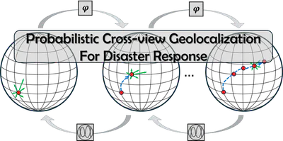
| Short description: | a Probabilistic Cross-view GeoLocalization approach designed to enable generative location awareness for rapid disaster response. |
| Lead developer: | Hao Li |
| Data: | Github |
| Further reading: | Please read the paper published in IJPRS |
| Citation: | Click to view the BibTeX entry@article{2026_ijprs_ProbGLC, author = {Li, Hao and Deuser, Fabian and Yin, Wenping and Knoblauch, Steffen and Zhao, Wufan and Biljecki, Filip and Xue, Yong and Huang, Wei}, doi = {10.1016/j.isprsjprs.2026.03.050}, journal = {ISPRS Journal of Photogrammetry and Remote Sensing}, pages = {130–145}, title = {Towards generative location awareness for disaster response: A probabilistic cross-view geolocalization approach}, volume = {237}, year = {2026} } |
Window Views dataset
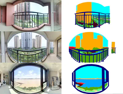
| Short description: | An open, manually annotated dataset of window views in a high density city (Wuhan, China). The original data was taken from the balcony window views of 300 apartments listed for sale in August 2022 on the Chinese real estate online marketplaces lianjia in August 2022. |
| Lead developer: | Chucai Peng |
| Data: | Github |
| Further reading: | Please read the paper published in Cities |
| Citation: | Click to view the BibTeX entry@article{2025_cities_windowviews, author = {Peng, Chucai and Xiang, Yang and Huang, Wenjing and Feng, Yale and Tang, Yongqi and Biljecki, Filip and Zhou, Zhixiang}, doi = {10.1016/j.cities.2024.105536}, journal = {Cities}, pages = {105536}, title = {Measuring the value of window views using real estate big data and computer vision: A case study in Wuhan, China}, volume = {156}, year = {2025} } |
Longitudinal thermographic dataset in Singapore
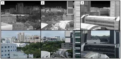
| Short description: | More than a million thermographic images collected in our campus from ground-based thermal cameras over a long time, allowing users to determine the temperature trend of individual features such as buildings, roads, and vegetation in a tropical environment. |
| Lead developer: | Subin Lin from NUS and the Berkeley Education Alliance for Research in Singapore (BEARS) |
| Data: | Github |
| Further reading: | Please read the paper published in Scientific Data |
| Citation: | Click to view the BibTeX entry@article{2023_sd_iris, author = {Lin, Subin and Ramani, Vasantha and Martin, Miguel and Arjunan, Pandarasamy and Chong, Adrian and Biljecki, Filip and Ignatius, Marcel and Poolla, Kameshwar and Miller, Clayton}, doi = {10.1038/s41597-023-02749-0}, journal = {Scientific Data}, pages = {859}, title = {District-scale surface temperatures generated from high-resolution longitudinal thermal infrared images}, volume = {10}, year = {2023} } |
EUropean BUilding stock Characteristics in a Common and Open database
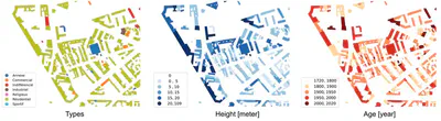
| Short description: | EUBUCCO is a scientific database of individual building footprints for 206 million buildings across the 27 European Union countries and Switzerland, together with three main attributes – building type, height and construction year – included for respectively 45%, 74%, 24% of the buildings. |
| Lead developer: | Nikola Milojevic-Dupont and Felix Wagner, Mercator Research Institute for Global Commons and Climate Change and TU Berlin |
| Website: | Website |
| Code: | Github repo |
| Data: | Zenodo |
| Further reading: | Please read the paper published in Scientific Data |
| Citation: | Click to view the BibTeX entry@article{2023_sd_eubucco, author = {Milojevic-Dupont, Nikola and Wagner, Felix and Nachtigall, Florian and Hu, Jiawei and Br{"u}ser, Geza Boi and Zumwald, Marius and Biljecki, Filip and Heeren, Niko and Kaack, Lynn H. and Pichler, Peter-Paul and Creutzig, Felix}, doi = {10.1038/s41597-023-02040-2}, journal = {Scientific Data}, number = {1}, pages = {147}, title = {EUBUCCO v0.1: European building stock characteristics in a common and open database for 200+ million individual buildings}, volume = {10}, year = {2023} } |
3D building metrics for urban morphology
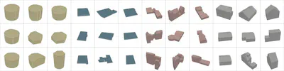
| Short description: | 3D Building Metrics. Elevating geometric analysis for urban morphology, solar potential, CFD etc to the next level |
| Lead developers: | Anna Labetski and Stelios Vitalis, 3D Geoinformation, TU Delft |
| Code: | Github repo |
| Data: | Repository |
| Further reading: | Please read the paper published in the International Journal of Geographical Information Science |
| Coverage: | Major cities in the Netherlands, extensible thanks to the code released open-source |
| Citation: | Click to view the BibTeX entry@article{2023_ijgis_3dbm, author = {Labetski, Anna and Vitalis, Stelios and Biljecki, Filip and Arroyo Ohori, Ken and Stoter, Jantien}, doi = {10.1080/13658816.2022.2103818}, journal = {International Journal of Geographical Information Science}, title = {3D building metrics for urban morphology}, year = {2023}, volume = {37}, issue = {1}, pages = {36-67} } |
3dfier: automatic reconstruction of 3D city models

| Short description: | Takes 2D GIS datasets (e.g. topographical datasets) and “3dfies” them (as in “making them three-dimensional”) by lifting every polygon to 3D |
| Lead developer: | 3D Geoinformation, TU Delft |
| Code: | Github repo |
| Further reading: | Please read more in the paper published in the Journal of Open Source Software |
| Citation: | Click to view the BibTeX entry@article{2021_joss_3dfier, author = {Ledoux, Hugo and Biljecki, Filip and Dukai, Balázs and Kumar, Kavisha and Peters, Ravi and Stoter, Jantien and Commandeur, Tom}, doi = {10.21105/joss.02866}, journal = {Journal of Open Source Software}, number = {57}, pages = {2866}, title = {3dfier: automatic reconstruction of 3D city models}, volume = {6}, year = {2021} } |
ifc2indoorgml
| Short description: | A tool allowing to generate IndoorGML files from IFC input models |
| Lead developer: | Abdoulaye Diakite, GRID, University of New South Wales |
| Code: | Github repo |
| Further reading: | Paper |
| Citation: | Click to view the BibTeX entry@article{2022_isprs_ifc2indoorgml, author = {Diakite, AA and Díaz-Vilariño, L and Biljecki, F and Isikdag, Ü and Simmons, S and Li, K and Zlatanova, S}, doi = {10.5194/isprs-archives-xliii-b4-2022-295-2022}, journal = {Int. Arch. Photogramm. Remote Sens. Spatial Inf. Sci.}, pages = {295–301}, title = {ifc2indoorgml: An open-source tool for generating IndoorGML from IFC}, volume = {XLIII-B4-2022}, year = {2022} } |
AIDA - Annotated Image Database of Architecture
| Short description: | A repository of architectural photographs worldwide, labelled with a vast list of hierarchical categories and a series of auxiliary annotations |
| Lead developer: | Chen Jielin |
| Further reading: | Paper |
| Download: | Harvard Dataverse |
| Main data source(s): | ArchDaily |
| Citation: | Click to view the BibTeX entry@inproceedings{2021_caadria_aida, author = {Chen, Jielin and Stouffs, Rudi and Biljecki, Filip}, booktitle = {Proceedings of the 26th International Conference of the Association for Computer-Aided Architectural Design Research in Asia (CAADRIA) 2021}, pages = {161–170}, title = {Hierarchical (Multi-Label) Architectural Image Recognition and Classification}, volume = {1}, year = {2021} } |