Vacancy: Postdoctoral research fellow in 3D underground modelling (1 position)
Job and project description
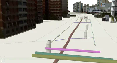
To create new space for its growing needs, Singapore is going underground. Reliable and accurate information of underground utilities is a key enabler of good and efficient decisions made by planners, land administrators, developers and engineers. Conversely, a lack of reliable information can lead to less than optimal use of underground space, lengthy and costly planning, design and development processes, and risks to critical infrastructure resilience workers’ safety. Due to a number of constraints and challenges, reliable information of underground utilities is often not captured, consolidated or shared in a sufficient manner. In this project, we aim to make a significant contribution to solving this pressing problem both in Singapore and globally. We will research, develop, demonstrate, and evaluate an integrated, rapid, and cost-effective workflow in a realistic setting. The workflow will comprise 1) capturing newly built and existing underground services and assets on-site, 2) providing a reliable 3D representation and associated documentation of these services and assets, and 3) their visualisation after covering up.
Starting in June 2020, you will work on the design, development, and testing of a data model and automated workflows for managing, processing, transforming, and utilising 3D information of underground assets.
You will join us in Singapore as part of an exciting new collaboration between the Singapore-ETH Centre, National University of Singapore, Singapore Government agencies, and ETH Zürich. Your work will tie in closely with Singapore’s Digital Underground programme.
Our group at NUS will carry out a part of the project that is focusing on the development of a data model and software tools for data representation, harmonisation, modelling, updating, and transformation between different formats (e.g. BIM/GIS) of 3D underground services.
The key tasks of this work package are:
- Data harmonisation: integrating underground services data from various sources (e.g. 2D GIS data, BIM, scan data).
- Multi-resolution modelling of underground data.
- Development of a data model.
- Data transformation, quality assurance, and preparation of the data for visualisation.
You will be part of the team of the work package (postdoctoral research fellow, two research assistants, and software developer), and collaborate with the broader project team comprising other work packages, which are focused on the acquisition of underground data and their visualisation.
You will be supervised by the work package leaders and co-principal investigators of the project Dr Filip Biljecki and Dr Patrick Janssen, NUS School of Design and Environment.
Scope and responsibilities
Your key responsibilities, besides the principal tasks of the work package listed above, will be:
- Leading the research on data modelling and developing automated workflows.
- Assisting the Co-PIs in the management of the project and supervision of team members.
- Preparation of publications and managing the research output.
Preferred qualifications
You should demonstrate that you possess:
- A PhD degree (or completed before the start of the project) in a related discipline from a reputable university.
- A solid publication record.
- Prior experience in modelling underground information and/or (3D) geographic data modelling.
- Excellent communication skills in English.
- Experience with programming (preferably Python and/or C/C++). Having built software used by others and/or scientific software experience is a plus.
- Familiarity with geospatial data (and 3D is a further plus), and GIS software/libraries, especially ETL tools such as FME.
- Understanding of data standardisation and interoperability.
- Capability of identifying and quickly learning the most suitable tools for the project on the go.
You’re not expected to be an expert in all of the above, and you don’t have to tick all the boxes to be considered a strong candidate. If you are well motivated and if you can demonstrate a successful track record in your previous experience, we offer a stimulating environment supporting you to further your skills and contribute to the project.
Our offer
- You will be working on a compelling project at the forefront of geographic information modelling.
- Work at the intersection of academia and practice, leveraging the best of both worlds: impactful work with ample opportunity to test and validate your work in the real-world or with real-world data, based on collaboration with Singapore Government agencies, contractors, and technology providers.
- Work in a research and educational environment where you may not only contribute to your own personal development, but also to others, especially through teaching and supervising students (for example, supervising master theses that may arise in connection to this project).
- Opportunity to make impactful contributions in the field, on a globally relevant topic.
- Visibility and exposure of your work.
- Flexible working environment.
- Exploring new technologies and opportunity to experiment with the state of the art.
- The remuneration will be determined according to the university’s salary range depending on the degree and experience.
Duration and start
The appointment is for two years. The start of the project is on 1 June 2020.
Location
The main campus of the National University of Singapore.
Employer
National University of Singapore
The National University of Singapore (NUS) is ranked consistently as one of the world’s top universities. It aspires to be a vital community of academics, researchers, staff, students and alumni working together in a spirit of innovation and enterprise for a better world.
Ranked as the #1 most competitive country and the safest country in the world, Singapore successfully attracts talents from all over the world by offering first-world living and working experience in the heart of Southeast Asia.
Urban Analytics Lab
The NUS Urban Analytics Lab is an interdepartmental multidisciplinary research group established in 2019 focusing on urban analytics, geographic data science, and 3D city modelling at the NUS School of Design and Environment. Our mission is to leverage on spatially enabled data for urban applications, catalyse the development of 3D geoinformation in the context of smart cities, make sense of big geospatial data and digital twins in the built environment, and cater to disciplines such as architecture, urban planning, and real estate to make informed decisions using 3D city models and urban analytics. The group is the first one in Singapore encompassing the entire 3D GIS ecosystem under the same roof: from standardisation and generation of 3D city models all the way to their utilisation and visualisation, while continuously exploring new frontiers in the field.
Application
Please apply through JobsBank or by email. Please submit the indication of possessing the qualifications listed above (CV, and optionally additional relevant material such as portfolio and cover letter), and do so preferably in PDF format. In accordance with the Personal Data Protection Act (PDPA), please provide consent for the collection, use and disclosure of personal data, using the NUS Personal Data Consent for Job Applicants form.
For more information, please visit NUS > Careers > Academic Appointments.
We appreciate your understanding that only applicants shortlisted for the interview will be notified. Shortlisted candidates will later be asked to provide the full documentation (e.g. copy of diploma, contacts of referees).
Contact
For more information please contact the co-principal investigator of the project Dr Filip Biljecki.