New paper: Exploration of open data in Southeast Asia to generate 3D building models
3D GeoInfo 2020 paper
We published a new paper:
Biljecki F (2020): Exploration of open data in Southeast Asia to generate 3D building models. ISPRS Annals of Photogrammetry, Remote Sensing and Spatial Information Sciences. VI-4/W1-2020: 37-44. 10.5194/isprs-annals-vi-4-w1-2020-37-2020 PDF
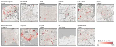
This article investigates the current status of generating 3D building models across 11 countries in Southeast Asia from publicly available data, primarily volunteered geoinformation (OpenStreetMap). The following countries are analysed: Brunei, Cambodia, Indonesia, Laos, Malaysia, Myanmar, Philippines, Singapore, Thailand, Timor-Leste, and Vietnam. This cross-country study includes multiple spatial levels of analysis: country, town, and micro-level (smaller neighbourhood). The main finding is that authoritative data to generate 3D building models is almost non-existent while building completeness in OpenStreetMap is highly heterogeneous, yielding location-dependent conclusions. While in general just a fraction of mapped buildings has height information and none of the administrative areas provides sufficient information to generate 3D building models, on a micro-level some areas are fully complete, providing a high potential to generate 3D building models on a precinct scale, which may be useful for certain spatial analyses. Furthermore, some areas have high building completeness, requiring only half of the work necessary for the extrusion: the collection of building height attributes. As a part of this work, a semantic 3D building model of a selected set of buildings in Singapore has been generated and released as open data (CityJSON), and the developed code was open-sourced.
For more information please see the paper (open access ).
BibTeX citation:
@article{2020_3dgeoinfo_3d_asean,
 author = {Biljecki, F},
 doi = {10.5194/isprs-annals-vi-4-w1-2020-37-2020},
 journal = {ISPRS Annals of Photogrammetry, Remote Sensing and Spatial Information Sciences},
 pages = {37--44},
 title = {{Exploration of open data in Southeast Asia to generate 3D building models}},
 volume = {VI-4/W1-2020},
 year = {2020}
}