Graduation projects completed at our Lab in 2021
Great job everyone, it was nice working with you
 Photo by Damiano Lingauri on Unsplash.
We are proud to announce that in the last few months, four students have completed their studies by carrying out a graduation project with us.
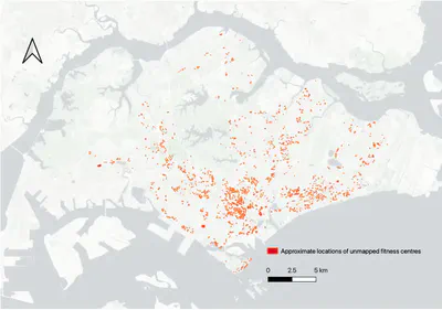
Exploiting real estate data for the enrichment of spatial databases
In her excellent thesis for the degree of MSc in Applied GIS, Xinyu Chen has researched extracting information on buildings and amenities from latent sources of data – property transactions and real estate ads. The work has resulted in an entirely new approach to collect spatial data, and it posits that real estate data may be considered as an uncovered type of volunteered geoinformation.
Her thesis was also published as a paper in Urban Informatics.
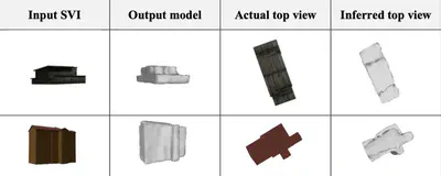
3D building reconstruction with sparse street view images using deep learning techniques
Street view imagery has been quite an interesting and relatively new source of urban data (e.g. read our recent review paper). However, it has not been used much for generating 3D city models. Further, because of vegetation and other obstacles, sometimes only one clear image of a particular building is available, inhibiting standard photogrammetric and other approaches. Therefore, new methods have to be developed for 3D building model reconstruction in such scenarios.
In her ambitious graduation project, Hui En Pang has developed a method to reconstruct 3D building models from single street view images. Following the completion of this successful research, at the intersection of computer vision, 3D modelling and geographic information science, Hui En has been awarded an MSc in Applied GIS.
The paper on her research was published in JAG.
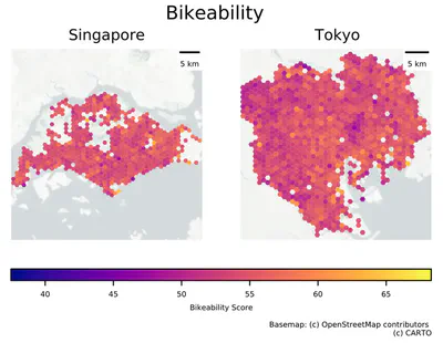
Usability of street view imagery in assessing bikeability
Koichi Ito graduated from the Master of Urban Planning with an interesting research on a new application of computer vision and street view imagery: assessing bikeability. Koichi’s excellent work has demonstrated the value of these technologies and datasets for virtual audits gauging the cycling appeal, widely and at a high resolution.
His thesis has been condensed into a paper – it has been published in TRC.
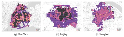
Classification of urban morphology with deep learning: A case study of its application on urban vitality prediction
Wangyang Chen graduated with a master degree from our MUP programme. He has done a great job on spearheading a new application of deep learning in urban analytics: characterising urban morphology and linking it to urban vibrancy. The code he developed has been released as open-source software.
Further, the paper based on his research was published in CEUS.
Congratulations to everyone on the awesome job and your degrees, well deserved 🎓 👏. We wish you all the best in your future career steps.