3D cadastreUrban Analytics Lab2019-09-26 
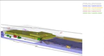
3D PDF, official document that visualized the multi-level property rights in 3D (case Delft Station). Source: Stoter et al. (2017). IJGI, 6(6): 158.Collaboration with Prof Jantien Stoter (TU Delft) and Dr Serene Ho (RMIT University).Urban Analytics LabPostsNew paper: How might an LoD Logic Framework Help to Bridge the 3D Cadastre Research-to-Practice Gap?
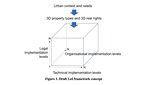
FIG Working Week 2020. A Proposal for a Level of Implementation FrameworkUrban Analytics Lab2020-09-15 2 min readProjectCurrent trends, challenges, and gaps of contemporary 3D cadastreA significant number of studies has been carried out to establish 3D cadastre solutions to improve the registration of multi-level propertyUrban Analytics Lab2019-09-26 2 min readProjectPublicationsHow might an LoD Logic Framework Help to Bridge the 3D Cadastre Research-to-Practice Gap? A Proposal for a Level of Implementation FrameworkDuring the past decade, hundreds of research papers have been published on the challenge of registering multi-level properties in land …Jantien Stoter, Filip Biljecki, Serene HoPDF Cite ProjectConsiderations for a contemporary 3D cadastre for our timesA significant number of studies has been carried out to establish 3D cadastre solutions to improve the registration of multi-level …Jantien Stoter, Serene Ho, Filip BiljeckiPDF Cite Project DOI