Large-scale 3D geospatial data for urban analytics
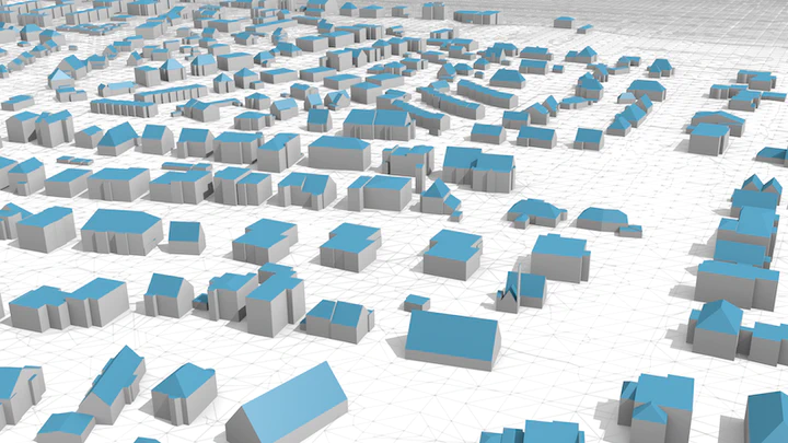 3D city model of Hamburg, Germany. Open dataset. Source: Biljecki F, Dehbi Y (2019). Raise the roof: towards generating LoD2 models without aerial surveys using machine learning. ISPRS Ann. Photogramm. Remote Sens. Spatial Inf. Sci., IV-4/W8: 27-34.
This five-year project is focused on devising a method to estimate individual building heights in the absence of traditional measurements such as lidar, to generate 3D city models solely from building footprints on a very large scale spanning scores of countries. It is funded by the National University of Singapore (with contributions by Amazon and Google), and it started in late 2019.
The project seeks to build on top of the method previously presented by the project PI, described in the journal paper:
Biljecki, F., Ledoux, H., & Stoter, J. (2017). Generating 3D city models without elevation data. Computers, Environment and Urban Systems, 64, 1–18. doi: 10.1016/j.compenvurbsys.2017.01.001
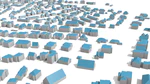
The work included developing a regression model (random forest) to estimate the heights of buildings from their footprints, using only 2D datasets, without remotely sensed data. This project aspires to scale the method to achieve global coverage and derive heights of individual buildings around the world. It will also investigate the potential addition of remotely sensed data. The targeted deliverables are a list of predicted heights attached to all buildings in OpenStreetMap, and a 3D building model in CityJSON in LoD1 generated using the OSM footprints and predicted heights, to facilitate their use in the geospatial domain and urban analytics.
This ongoing project also includes accompanying research sub-projects, such as:
- Developing a method to assess the global building completeness in OSM.
- Understanding the quality of heights already available in OSM, which can be used as training data.
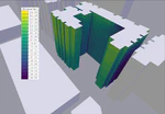
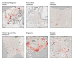
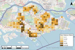
- Exploring use cases relying on the availability of such dataset (e.g. population estimation, or shadow analyses like in the image below).
- Using machine learning to infer the roof type of buildings, leading to the generation of highly detailed building models (as in the image in the header above). This portion has already been investigated, and a paper has been published.
 and [VI-Suite + Blender](https://doi.org/10.1186/s40965-017-0036-1))](/project/3d-open/hdb-solar_hu0466d627a08660860186c9dd84523c75_763059_19536fb83887db4aebd1d3c5859449c7.webp)
Filip Biljecki
Assistant Professor
Yoong Shin Chow
Research Assistant
Abraham Noah Wu
PhD Researcher
Kay Lee
Undergraduate Student
Koichi Ito
PhD Researcher
Lawrence Chew Zheng Xiong
Undergraduate Student
Shiyue Zhong
Graduate Student
Ankit Palliwal
Graduate Student
Ang Li Min
Undergraduate Student
Jin Yuchen
Undergraduate Student
Posts


Publications