Article-Journal

Assessing governance implications of city digital twin technology: A maturity model approach

Digital twin technology has great potential to transform urban planning. However, the governance aspects of city-scale digital twins (CDTs)— a virtual representation of urban environments —are understudied. This study bridges this knowledge gap by adopting a framework that scrutinizes the maturity stages of technology. We introduce the CITYSTEPS Maturity Model, a pioneering maturity framework tailored for CDTs, to assess all development stages of CDTs, including those utilizing artificial intelligence, and analyze the technology’s role in urban governance. We highlight the promise of CDTs in enhancing public participation in urban planning and addressing key smart city concerns, such as accountability and transparency. However, significant challenges remain, including public participation, public trust in privacy protection, and technical impediments like inadequate data integration, systems integration, and interoperability. There’s also the pressing issue of social inclusion: the potential exclusion of marginalized groups, including those often overlooked in data collection, like the hidden homeless and informal sector workers. We propose CDTs should be designed with a human-centric approach, transparent and unbiased data collection and algorithm development, and be led by an adaptive regulatory framework. The CITYSTEPS Maturity Model lays out a framework to assess CDTs’ present state, forecast their future, and understand their governance implications, promoting more inclusive technology adoption.

Assessing governance implications of city digital twin technology: A maturity model approach
Mapping the landscape and roadmap of geospatial artificial intelligence (GeoAI) in quantitative human geography: An extensive systematic review

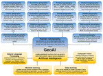
This paper brings a comprehensive systematic review of the application of geospatial artificial intelligence (GeoAI) in quantitative human geography studies, including the subdomains of cultural, economic, political, historical, urban, population, social, health, rural, regional, tourism, behavioural, environmental and transport geography. In this extensive review, we obtain 14,537 papers from the Web of Science in the relevant fields and select 1516 papers that we identify as human geography studies using GeoAI via human scanning conducted by several research groups around the world. We outline the GeoAI applications in human geography by systematically summarising the number of publications over the years, empirical studies across countries, the categories of data sources used in GeoAI applications, and their modelling tasks across different subdomains. We find out that existing human geography studies have limited capacity to monitor complex human behaviour and examine the non-linear relationship between human behaviour and its potential drivers—such limits can be overcome by GeoAI models with the capacity to handle complexity. We elaborate on the current progress and status of GeoAI applications within each subdomain of human geography, point out the issues and challenges, as well as propose the directions and research opportunities for using GeoAI in future human geography studies in the context of sustainable and open science, generative AI, and quantum revolution.

Mapping the landscape and roadmap of geospatial artificial intelligence (GeoAI) in quantitative human geography: An extensive systematic review