Local Climate Zones: Lessons from Singapore and potential improvement with street view imagery
Abstract
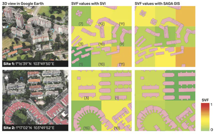
Urban heat island (UHI) is considered a serious environmental issue in highly urbanized cities such as Singapore. To better quantify the UHI intensity, the local climate zones (LCZ) classification scheme was adopted to characterize land covers, and describe and compare their thermal performance. There are three commonly used LCZ classification approaches: manual sampling,World Urban Database and Access Portal Tools (WUDAPT) processing method using remote sensing, and geographical information system (GIS)-based method. Based on the current implementation of WUDAPT Level 0 method in the classification work in Singapore, the principal limitations are expounded. To overcome the deficiencies, street view imagery (SVI), which carries substantial urban spatial information, is regarded as a promising data source. This paper reviews the potential of SVI to better estimate certain LCZrelated properties, such as sky view factor (SVF). As it allows a detailed view on the ground objects, SVI opens up the possibility of identifying surface properties such as albedo, as well as anthropogenic heat sources. Although it is not a novel idea, there has been a lack of a comprehensive use of SVI in assisting LCZ classification from the ground up, especially in a high-density city such as Singapore. This paper overviews potential ways to incorporate SVI and identifies challenges such as coarse temporal resolution and spatial coverage constrained to drivable roads.