Sensitivity of measuring the urban form and greenery using street-level imagery: A comparative study of approaches and visual perspectives
Abstract
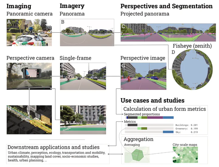
Street View Imagery (SVI) is crucial in estimating indicators such as Sky View Factor (SVF) and Green View Index (GVI), but (1) approaches and terminology differ across fields such as planning, transportation and climate, potentially causing inconsistencies; (2) it is unknown whether the regularly used panoramic imagery is actually essential for such tasks, or we can use only a portion of the imagery, simplifying the process; and (3) we do not know if non-panoramic (single-frame) photos typical in crowdsourced platforms can serve the same purposes as panoramic ones from services such as Google Street View and Baidu Maps for their limited perspectives. This study is the first to examine comprehensively the built form metrics, the influence of different practices on computing them across multiple fields, and the usability of normal photos (from consumer cameras). We overview approaches and run experiments on 70 million images in 5 cities to analyse the impact of a multitude of variants of SVI on characterising the physical environment and mapping street canyons: a few panoramic approaches (e.g. fisheye) and 96 scenarios of perspective imagery with variable directions, fields of view, and aspect ratios mirroring diverse photos from smartphones and dashcams. We demonstrate that (1) disparate panoramic approaches give different but mostly comparable results in computing the same metric (e.g. from R=0.82 for Green View to R=0.98 for Sky View metrics); and (2) often (e.g. when using a front-facing ultrawide camera), single-frame images can derive results comparable to commercial panoramic counterparts. This finding may simplify typical processes of using panoramic data and also unlock the value of billions of crowdsourced images, which are often overlooked, and can benefit scores of locations worldwide not yet covered by commercial services. Further, when aggregated for city-scale analyses, the results correspond closely.