Our public seminars
The Urban Analytics Lab seminar series is part of our community engagement to provide a platform leading to discussions, new ideas, and spurring collaborations. In our series, besides hosting seasoned researchers and professors, we also feature early career researchers (e.g. junior faculty) to increase their visibility and learn about the latest exciting ideas.
For the full list of events at our NUS Department of Architecture see the list of events.
Please note that, to facilitate an enhanced atmosphere, engagement and interaction, the talks are only in-person at our NUS College of Design and Engineering (they are not streamed online) and they are not recorded.
To stay updated, please follow our LinkedIn account.
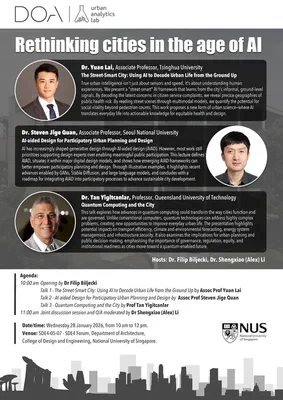
2026-01-28 — Rethinking cities in the age of AI
Departing from the usual format, this time, we are hosting a joint seminar with guests from Australia, Korea, and China:
- The Street-Smart City: Using AI to Decode Urban Life from the Ground Up, by Assoc Prof Yuan Lai, Tsinghua University
- AI-aided Design for Participatory Urban Planning and Design, by Assoc Prof Steven Jige Quan, Seoul National University
- Quantum Computing and the City, by Prof Tan Yigitcanlar, Queensland University of Technology
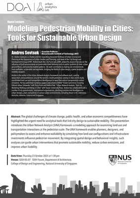
2025-10-23 — Modeling Pedestrian Mobility in Cities: Tools for Sustainable Urban Design
By Andres Sevtsuk, Department of Urban Studies and Planning, Massachusetts Institute of Technology, USA
The global challenges of climate change, public health, and urban economic competitiveness have highlighted the urgent need for analytical tools that link city design to sustainable mobility. This presentation introduces the Urban Network Analysis (UNA) framework—a modeling approach for examining land-use and transportation interactions at the pedestrian scale. The UNA framework enables planners, designers, and policymakers to assess and enhance walkability by simulating how land-use configurations and infrastructure investments influence pedestrian movement. By integrating spatial design and behavioral insights, such analyses can guide urban interventions that promote sustainable mobility, reduce carbon emissions, and improve urban livability.
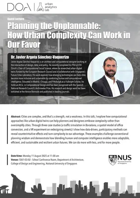
2025-08-11 — Planning the Unplannable: How Urban Complexity Can Work in Our Favor
By Javier Argota Sánchez-Vaquerizo, Computational Social Science, ETH Zurich, Switzerland
Cities are complex, and that’s a strength, not a weakness. In this talk, I explore how computational approaches like urban digital twins can help planners and designers embrace complexity rather than oversimplify cities. Through three case studies (a traffic simulation in Barcelona, a spatial model of office conversion, and a VR experiment on redesigning streets) I show how data-driven, participatory methods can reveal counterintuitive effects and turn complexity to our advantage. These examples challenge conventional planning wisdom and demonstrate how blending human and computer intelligence enables more adaptable, efficient, and sustainable and resilient urban futures. We can do more with less, and for more people.
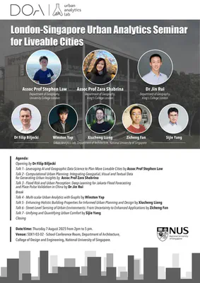
2025-08-07 — London-Singapore Urban Analytics Seminar for Liveable Cities
Departing from the usual format, this time, we are hosting a joint seminar with guests from the King’s College London and University College London, UK, including 7 presentations:
- Leveraging AI and Geographic Data Science to Plan More Liveable Cities, by Assoc Prof Stephen Law
- Computational Urban Planning: Integrating Geospatial, Visual and Textual Data for Generating Urban Insights, by Assoc Prof Zara Shabrina
- Flood Risk and Urban Perception: Deep Learning for Jakarta Flood Forecasting and Place Pulse Validation in China, by Dr Jin Rui
- Multi-scalar Urban Analytics with Graphs, by Winston Yap
- Enhancing Holistic Building Properties for Informed Urban Planning and Design, by Xiucheng Liang
- Street-Level Sensing of Urban Environments: From Uncertainty to Enhanced Applications, by Zicheng Fan
- Unifying and Quantifying Urban Comfort, by Sijie Yang
2025-07-23 — Evaluating Urban Ventilation Corridor through Mobile Air Quality Monitoring and Environmental Justice
By Ye Tian, School of Geography, University College Dublin, Ireland
More than 99% of the population’s exposure to air pollution exceeds WHO guidelines, and approximately 4.2 million deaths are attributed to ambient air pollution annually. Fortunately, effective urban ventilation can facilitate the dispersion of air pollutants and mitigate potential health hazards. This need arises from the desire to gain detailed insights into the distribution of Urban Ventilation Corridors (UVCs) and their effects on air pollution dispersion, as well as to facilitate effective management strategies. This talk will introduce the UVC extraction through 2D and 3D urban morphological elements and UVC evaluation by: 1). comparing hyperlocal spatiotemporal variation of air pollutants through mobile monitoring; 2). quantifying the environmental justice of air pollution exposure for different socio-economic communities; and 3). leveraging the explainable machine learning models (GeoAI, Geospatial Artificial Intelligence) to predict air pollution levels and evaluate the UVC effects in detail.

2025-07-14 — Multimodal Earth Vision and Artificial Intelligence Techniques for Natural Hazard Risk and Impact Assessment
By Christian Geiß, Earth Observation Center, German Aerospace Center, Germany
Global changes encompass human-driven alterations to the Earth system. These changes include increasing urbanization and the frequent increase of exposure and vulnerability with respect to natural hazards such as earthquakes, tsunamis, or flood events. Existing models often allow solely a very coarse estimation of risks as they rely on either highly aggregated or outdated input data. This situation is exacerbated as urbanization processes dramatically reshape settlement areas within a very short timeframe. Consequently, it is often challenging to quantify and anticipate the risks and potential consequences of natural hazards. In this context, I demonstrate the use of artificial intelligence techniques in conjunction with innovative geospatial data for natural hazard risk and impact assessment.

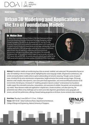
2025-06-05 — Urban 3D Modeling and Applications in the Era of Foundation Models
By Wufan Zhao, Urban Governance and Design Thrust, The Hong Kong University of Science and Technology (Guangzhou), China
Foundation models are transforming how cities are sensed, modeled, and understood. This presentation focuses on urban 3D modeling in the era of large-scale AI, highlighting how vision-language models, 3D generative architectures, and remote sensing foundation models enhance spatial understanding and semantic reasoning. Through a series of research cases—including 3D city scene reconstruction and generation, height estimation from remote sensing images, 3D change detection under complex urban dynamics, cross-scene point cloud segmentation, and immersive VR-based evaluation of 3D environments—the talk gives a framework of “modeling–perception–dynamic analysis” to demonstrate how foundation models support the automated construction, interpretation, and assessment of scalable, fine-grained, and semantically rich city models. These advances enable new applications in digital twins, climate simulation, and urban planning. The presentation also reflects on key challenges such as multi-source data alignment, generalization across geography and sensors, and real-time performance, offering a forward-looking perspective on AI-driven, human-centered urban modeling.
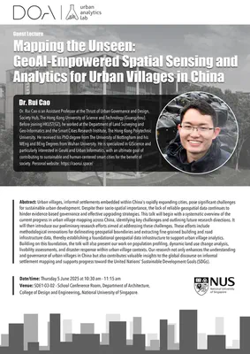
2025-06-05 — Mapping the Unseen: GeoAI-Empowered Spatial Sensing and Analytics for Urban Villages in China
By Rui Cao, Urban Governance and Design Thrust, The Hong Kong University of Science and Technology (Guangzhou), China
Urban villages, informal settlements embedded within China’s rapidly expanding cities, pose significant challenges for sustainable urban development. Despite their socio-spatial importance, the lack of reliable geospatial data continues to hinder evidence-based governance and effective upgrading strategies. This talk will begin with a systematic overview of the current progress in urban village mapping across China, identifying key challenges and outlining future research directions. It will then introduce our preliminary research efforts aimed at addressing these challenges. These efforts include methodological innovations for delineating geospatial boundaries and extracting fine-grained building and road infrastructure data, thereby establishing a foundational geospatial data infrastructure to support urban village analytics. Building on this foundation, the talk will also present our work on population profiling, dynamic land use change analysis, livability assessments, and disaster response within urban village contexts. Our research not only enhances the understanding and governance of urban villages in China but also contributes valuable insights to the global discourse on informal settlement mapping and supports progress toward the United Nations’ Sustainable Development Goals (SDGs).
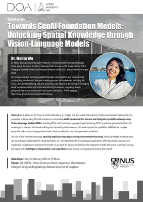
2025-02-14 — Towards GeoAI Foundation Models: Unlocking Spatial Knowledge through Vision-Language Models
By Meiliu Wu, School of Geographical & Earth Sciences, University of Glasgow, Scotland
As AI advances, the fusion of multimodal data (e.g., images, text, and spatial information) unlocks unprecedented opportunities for geospatial understanding. This talk introduces an innovative GeoAI framework that extracts and integrates spatial knowledge using Vision-Language Models (VLMs), including GPT-4 and Contrastive Language-Image Pretraining (CLIP), to enhance geospatial analytics. By enabling AI to interpret both visual and linguistic data with spatial awareness, this work expands the capabilities of AI to tackle complex geospatial tasks, such as image geo-localization, land use detection, and urban perception prediction. The core of this framework leverages spatially explicit prompt engineering and contrastive learning, refining AI models to reason about geo-locations and spatial patterns. These techniques set a new benchmark for AI in geospatial applications, offering scalable, accurate, and explainable insights across diverse environments. As we push the boundaries of GeoAI, the integration of VLMs and spatial reasoning is paving the way for more intelligent, interpretable, and impactful decision-making in the geospatial domain and beyond.
2024-10-21 — From Built Heritage 3D Spatial Documentation to National Hazards Maps: a multi-scale & multi-techniques research approach
By Elisabetta Colucci, Department of Architecture and Design, Politecnico di Torino, Italy
It is now widely recognized that digital methods and techniques significantly aid the spatial documentation of cultural heritage. Thanks to innovative instruments, algorithms (from computer vision), and approaches (from artificial intelligence), it is possible to carry out 2D and 3D spatial documentation of built heritage and structures, ranging from architectural to territorial and landscape scales, with a multi-level-of-detail approach. National and international standards also enable the spatial and semantic documentation of cities, villages, and cultural heritage, helping to prevent damage and support urban planning, restoration efforts, structural design, monitoring studies, and more. Furthermore, open data, spatial databases, and interdisciplinary collaboration for analyzing these data offer a wealth of spatial data and parameters that assist in studying and analyzing risks and vulnerabilities in territorial areas and critical infrastructures, particularly related to natural hazards and climate change-induced risks.
2024-09-17 — Greener Urban Trips for Everyone: From Measured Wellbeing Impacts to Big Data Analytics
By Tuuli Toivonen, Digital Geography Lab, University of Helsinki, Finland
The presentation focuses on analysing the availability of greenery in urban travel environments from various perspectives. It will present the ongoing work of a large European Research Council funded project GREENTRAVEL, which aims at producing novel understanding of the quality, availability and wellbeing impacts of green urban travel environments. The project employs technologies from immersive Virtual Reality to Big Data mining to understand the importance of green exposure during everyday travels and to identify relevant greenery features across seasons. To scale to entire urban areas without losing the human street view perspective, the project employs computer vision on street-view images and 3D models to map relevant greenery features. Furthermore, mobile Big Data is being leveraged to study the mobility flows of the urban population and to reveal the equity of green exposure during these everyday trips, also considering different transportation modes. The presentation will describe the ongoing work of the project and more broadly the urban research at the Digital Geography Lab, hopefully providing a platform for fruitful discussions.
2024-07-17 — What happens with big data approaches to urban science when data don’t exist?
By Fábio Duarte, MIT Senseable City Lab, Massachusetts Institute of Technology, USA
As layers of networks and digital information blanket urban space, new approaches to the study of the built environment are emerging. We produce data permanently, in each personal and social interaction, and all devices produce and run on data. We could say we’re inundated in data, and within this scenario novel techniques have emerged in recent years to make sense of this data. But what happens when data don’t exist? We might be not be addressing critical contemporary issues because we don’t have machine-readable data available. In this talk I will show how the Senseable City address this challenge.
2024-07-16 — Twenty years of using crowd-sourced geodata to analyze urban phenomena – where do we go next?
By Ate Poorthuis, Department of Earth and Environmental Sciences, KU Leuven, Belgium
In the last twenty years we have seen the proliferation of all kinds of new digital data sources. From early Web 2.0 internet social media such as Foursquare and Facebook, crowd-sourced platforms like Wikipedia and OpenStreetMap, to contemporary mainstays such as Instagram and Tiktok. These platforms have touched and changed the way we live our lives, but they have also altered how we study urban phenomena. In this presentation, I first take a reflective look at how data from digital platforms has been used to study our cities, and how people live within them, for the past two decades. As we have moved beyond the initial hype and with the increased attention for the privacy and ethics implications of using digital data, I then look ahead to the next phase of urban research with this kind of data and identify a set of propositions that can help shape this next phase in a productive manner. In doing so, I will weave together a reflective and critical look on the work I have done together with collaborators over the last decade with a perspective on where our research agenda (hopefully) brings us in the next years.
2024-07-15 — Ethics and Responsible Innovation in Data-Intensive Smart Cities and Urban Mobility Management
By Vonu Thakuriah, Rutgers Urban and Civic Informatics Lab, Rutgers University-New Brunswick, USA
Data and information technology have transformed our daily lives and have reshaped the ways in which cities and transportation systems are governed and operated. But too often, urban and mobility analytics is couched narrowly in terms of resource optimization and management on the one hand, and privacy and surveillance on the other. While efficiency and data protection are essential criteria in delivering urban services, there is a need to ensure that data-driven tools and technologies contribute to social justice and are not used to harm vulnerable populations. Currently, there is an increasing focus on bias and algorithmic justice with the aim of steering data-driven systems towards fairness-by-design, data democracy, and data justice, across a wide spectrum of data-driven technology (big data, AI, machine learning). These are consequential future directions since inadequate data and misspecified and myopic algorithms can cause harm and reinforce existing inequities. Using heterogeneous sources of structured and unstructured data in the context of contested streets and uneven transportation access, the talk will highlight the technological, methodological, and epistemological pillars of data-intensive smart city and urban mobility systems, with an emphasis on the power dynamics and political economy of urban data production, and the unintended consequences and governance challenges associated with such systems.
2024-07-08 — User-Generated Data: Alternative Data Source for Urban Planning in Indonesia
By Adiwan Fahlan Aritenang, Urban and Regional Planning Program, Institut Teknologi Bandung, Indonesia
In Indonesia, limited data availability has led to the lack of accuracy and ineffectiveness urban planning. Geographic and statistics data are not reliable due to variation between institutions and unclear collection methodologies. Following technology advancement, user-generated data (UGD) presents a valuable alternative to address this issue. UGD information are created and shared by individuals through various platforms such as search engines, social media, and maps. As the data are abundant, diverse, and continuously updated which offering real-time insights, USD allows urban researchers and policymakers to gain more comprehensive understanding of public interest and opinions, behaviors, and geographical trends. Furthermore, UGD is cost-effective compared to conventional data collection methods like surveys and censuses. In Indonesia where formal data collection mechanisms may be underdeveloped or constrained by geographic and logistical challenges, UGD is a solution. The UGD provides rich, timely, and diverse data source that helps urban planners to understand current situation and support decision-makers for a more responsive governance and development strategies.
2024-05-13 — Advancing Sense of Place with Human-centered Geospatial Data Science
By Yuhao Kang, Department of Geography, University of South Carolina, USA
Human sense of place refers to how we perceive, experience, and interact with a particular location and environment. The emergence of Geospatial Data Science – the use of geographic knowledge and AI approaches to extract meaningful insights from large-scale geographic data – has achieved remarkable success not only in modeling physical geographic phenomena but also in advancing human subjective experiences at place. In this talk, Dr. Kang will present a series of works that utilize geospatial data science to understand human experience and sense of place. First, utilizing eye-tracking systems, his work delved into human subjective safety perceptions (e.g., whether a neighborhood is perceived as a safe place) to identify physical objects that attract human attention from street view images. Second, utilizing large language models (LLMs), his work proposed a Soundscape-to-Image Diffusion model to visualize and translate human auditory perceptions into visual representations of place. His work demonstrated how human multi-sensory experiences can be linked to comprehensively understand human sense of place using Generative AI. Finally, he will share his multifaceted experiences in GISphere that aim to promote global GIScience education.
2023-12-18 — Opportunities and Challenges in Geospatial AI
By Song Gao, Geospatial Data Science Lab, University of Wisconsin - Madison, USA
Geospatial artificial intelligence (GeoAI), an emerging interdisciplinary field, merges geographic knowledge with AI techniques to address significant scientific and engineering challenges in human-environmental systems. It focuses on enhancing machines’ spatial intelligence to improve dynamic perception, intelligent reasoning, knowledge discovery and mapping of geographic phenomena. This talk will introduce the historical roots of GeoAI, delve into the latest advancements in spatially explicit AI models, and examine innovative research and applications of GeoAI, as well as addressing some challenges associated with GeoAI foundation models.
2023-10-02 — Realising Computational Design of Complex Geometry in Architecture
By Ming Shan (Charmaine) Ng, Center for the Possible Futures, Kyoto Institute of Technology, Japan
The talk showcases research and practice about computational design and digital fabrication of complex architecture. It explains how architects in Europe, America and Asia realised computational design of complex geometry building envelopes and structures with some of her past international projects in practice as examples. Dr. Ng introduces multiple key techniques in design practices, such as Design for Manufacture and Assembly (DfMA) and post-rationalisation through computational approaches, industrialised construction methods such as modularisation, prefabrication and digital fabrication, as well as integrated design management approaches such as lean-based Target Value Design, early contractor involvement, Integrated Project Delivery (IPD) and relational contracting. She also presents her research in correspondence to the above topics and demonstrates how scientific research can guide current practice to foster digital transformation, sustainability and circularity. Besides, she discusses her theoretical research on socio-technical network studies using the Actor-Network Theory (ANT) and transdisciplinary studies on liabilities and governance in technology implementation.
2023-09-18 — Cities on the Climate Frontlines: Evaluating Urban Climate Change and Policy Responses
By Angel Hsu, Data-Driven EnviroLab, The University of North Carolina at Chapel Hill, USA
Cities are both contributors and potential problem solvers of the global climate crisis. They are also vulnerable to climate change impacts, including sea-level rise, extreme heat, and natural disasters. Consequently, they have risen to become prominent climate and environmental sustainability agents, with the UN’s Sustainable Development Goal 11 charging cities to be both sustainable and inclusive and the Paris Agreement’s recognition of their contributions. In this talk, I’ll introduce how my research is utilizing data science to evaluate cities’ contributions to global climate mitigation efforts and urban sustainable development more broadly.
2023-08-07 — Experiencing the Future of Cities through Virtual Reality
By Gamze Dane, Department of Built Environment, Eindhoven University of Technology, the Netherlands
To achieve sustainable, inclusive, and livable cities, it is necessary for citizens and urban planning stakeholders to efficiently experience, discuss, and comprehend the consequences of various alternative urban intervention scenarios. This process serves two key purposes: (i) enhancing the planning practice by fostering participation and communication among stakeholders and citizens, and (ii) facilitating informed decision-making in urban planning. To this end, Virtual Reality (VR) technology offers a promising solution by providing immersive and experiential tools that allow users to envision and explore the future of cities through simulated environments. This presentation will showcase examples of projects where VR technology was utilized to
- support participatory design processes. Through the development of an interactive immersive VR application, users were enabled to experience, create, and discuss different design options for healthy public space design.
- gather data by tracking users’ behavior and choices within virtual environments that represent future urban scenarios. These insights are then used as input for agent-based models, which will predict the acceptance and use of future urban interventions.
2023-07-10 — Sensing Cities with Street-level Imagery
By Zhang Fan, Department of Civil and Environmental Engineering, Hong Kong University of Science and Technology, Hong Kong SAR
The integration of digital technologies into the physical space has led to significant changes in our understanding, perception, design, and experience of cities. The advent of geospatial big data and advancements in AI have created new possibilities for sensing urban dynamics and evaluating the effects of urbanization.
One type of geospatial data that has attracted attention recently is street-level imagery, which enables urban physical environment to be observed from a human perspective. Recent developments in AI technologies have provided strong support for extracting semantic information from street-level imagery and quantifying urban physical environment, which not only observing urban physical environment from the human perspective, but also reveals human activities and socio-economic environments, providing new perspectives for the research on human-land relationships and spatial data mining and knowledge discovery.
This presentation will introduce case studies of street-level imagery under the framework of urban visual intelligence.
2023-04-12 — Urban Analytics and Social Sensing
By Wei Huang, College of Surveying and Geo-Informatics, Tongji University, China
Analyzing massive urban human behaviour datasets helps to quantitatively understand the complexity of urban systems and social networks, which can further provide evidence for urban planning and policy making towards urban sustainable development. This talk reports data-driven models and applications for understanding the interactions between human activities and urban environments.
2023-04-10 — Artificial Intelligence for accelerating low-carbon planning
By Nikola Milojevic, TU Berlin and the Mercator Research Institute on Global Commons and Climate Change, Germany
In this talk, I discuss the potential of geospatial data and AI to analyze cities in novel ways and provide insights that can help governments to take action on climate change. I will introduce a framework that combines data sources, models and end goals, which I will exemplify by highlighting recent research of our group.
2023-03-06 — Map Outside the Box Pixel
By Yuhao Lu, Future Cities Laboratory, Singapore-ETH Centre, Singapore
Pixels (picture elements) are the smallest unit of raster-based maps.
Remote sensing and some geographic information analysis rely on pixels to store information, simulate changes, and communicate empirical findings.
Pixels are a fundamental cartographic unit, essential to many if not all mapping exercises.
However pixels can also pose constraints to our research and creative work, for example, due to their sizes (resolution), or the way they have been arranged and/or analysed. In this presentation, titled “Map Outside the box Pixel”, I will share two projects and a few maps that used pixels rather creatively, unlocking new ways to conduct pixel-based geospatial research and creative design projects.
These projects are technical by nature, but also creative in ways that I hope can speak to individuals who are not trained in geospatial sciences.
2023-02-27 — Urban shade planning for thermally sustainable cities: perspectives from multi-sensor analysis
By Park Yujin, Department of Urban Planning and Real Estate, Chung-Ang University, South Korea
Devising a nature- and design-based solution to combat climate challenges is a very important issue in urban planning to step up urban sustainability. Recent technological advances and the proliferation of big geospatial data allow for a more sophisticated digital representation of urban geometry in 3D. One underexplored but critical aspect is the impact of vertical urban features and their shading. Shading objects, including trees and buildings, are generally omnipresent in cities and can be utilized by urban planners to create effective local and regional plans for urban cooling. This talk addresses the interface of 3D land-use design and heat mitigation via diurnal shading, integrating geospatial analytics (3D GIS, spatial simulation and statistics) and remotely-sensed multi-resolution thermal data as a methodological tool. Based on a fine-resolution 3D model derived mainly from LiDAR, the relationship among land surface temperature, land cover composition, and shade characteristics are analyzed using statistical inference. The talk proposes challenges and research agendas that call for collaboration across domains (e.g. GIScience, energy, economics) to create sustainable land-use designs.
2023-02-02 — The Eco-Race in Architecture Caught Between Environmental Intuition and Intelligence
By Jonathan Natanian, Faculty of Architecture and Town Planning, Technion – Israel Institute of Technology, Israel
The race towards sustainability in the built environment is on! Zero carbon by 2050 and limiting global warming to 1.5 C are just some of the ambitious thresholds we need to get to – but how do we get there by design? Many claim that we should get back to the environmental architectural intuition we once had – but will it be enough? others push toward fully-digitized environmental design workflows – but what will happen then? This lecture will discuss some of these questions which revolve around the gaps between environmental intuition and intelligence in Architecture from personal, local, and global eco-race perspectives.
2023-01-03 — Addressing the Urban Planning Challenges Using GeoAI
By Vaibhav Kumar, Department of Data Science and Engineering, Indian Institute of Science Education and Research Bhopal, India
The world is witnessing tremendous planned and unplanned urban growth. More than 50% of the population will reside in urban centres in the next decade. The existing cities are witnessing a lot of challenges in many areas such as housing, health, climate, disaster, and transportation, to name a few. If not addressed now, these challenges will be even more pragmatic in the coming future, especially in the urban centers of developing countries. Geospatial Artificial Intelligence (GeoAI), which combines spatial data with artificial intelligence offers unique solutions to various urban issues. This talk aims to cover studies from GeoAI Research Lab, IISER Bhopal, which aim to solve multiple urban planning problems such as transportation, waste management, safety, disaster management, quality of life, etc.
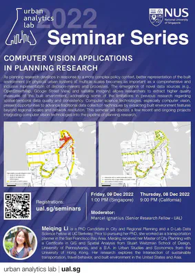
2022-12-09 — Computer Vision Applications in Planning Research
By Meiqing Li, College of Environmental Design, University of California, Berkeley, USA
As planning research develops in response to a more complex policy context, better representation of the built environment (or physical urban system) at multiple scales becomes as important as a comprehensive and inclusive representation of decision-makers and processes. The emergence of novel data sources (e.g., OpenStreetMap, Google Street View, and satellite imagery) allows researchers to extract higher quality measures of the built environment, addressing some of the limitations in previous research regarding spatial-temporal data quality and consistency. Computer science technologies, especially computer vision, present opportunities to advance traditional data collection techniques by extracting built environment features beyond regional scales and network resolution. This seminar will discuss a few recent and ongoing projects integrating computer vision technologies into the pipeline of planning research.
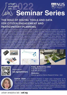
2022-11-25 — The role of digital tools and data for citizen engagement and participatory planning
By Gamze Dane, Department of Built Environment, Eindhoven University of Technology, & Digital City Program at the Urban Development Initiative, the Netherlands
As a response to centralized and rationalistic urban planning approaches that are unresponsive to citizens’ needs, participatory planning methods have emerged to design and plan urban environments with people for people. In recent years, there has been a rapid increase in the design, use, and adoption of digital tools (i.e. digital twins, VR, information dashboards) and the produced data (i.e. digital tracking, social media data, big data from sensory experiences) for supporting participatory decision-making in urban planning. These technologies assist citizen engagement and participatory planning in order to understand the status quo in urban areas, communicate potential changes, co-design future urban areas and reach consensus for inclusive, livable and sustainable urban environments. In this talk, I will present my current research interests in digital participatory planning. The presentation will cover the topics of (i) developing and applying digital tools and citizen science methods for supporting public participation and citizen engagement in urban transformation processes, (ii) performing urban (big) data science within people as sensors concept for understanding and predicting citizens’ behavior, opinions and experiences towards urban interventions.
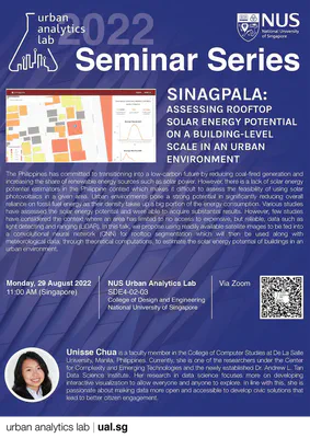
2022-08-29 — Sinagpala: Assessing Rooftop Solar Energy Potential on a Building-level Scale in an Urban Environment
By Unisse Chua, Center for Complexity and Emerging Technologies, College of Computer Studies, De La Salle University, the Philippines
The Philippines has committed to transitioning into a low-carbon future by reducing coal-fired generation and increasing the share of renewable energy sources such as solar power. However, there is a lack of solar energy potential estimators in the Philippine context which makes it difficult to assess the feasibility of using solar photovoltaics in a given area. Urban environments pose a strong potential in significantly reducing overall reliance on fossil fuel energy as their density takes up a big portion of the energy consumption. Various studies have assessed the solar energy potential and were able to acquire substantial results. However, few studies have considered the context where an area has limited to no access to expensive, but reliable, data such as light detecting and ranging (LiDAR). In this talk, we propose using readily available satellite images to be fed into a convolutional neural network (CNN) for rooftop segmentation which will then be used along with meteorological data, through theoretical computations, to estimate the solar energy potential of buildings in an urban environment.
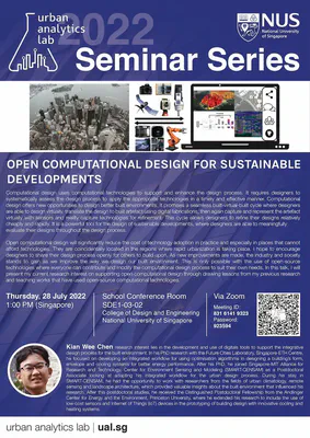
2022-07-28 — Open Computational Design for Sustainable Developments (in person at NUS + online)
By Kian Wee Chen, CHAOS Lab, Andlinger Center for Energy and the Environment, Princeton University, USA
Computational design uses computational technologies to support and enhance the design process. It requires designers to systematically assess the design process to apply the appropriate technologies in a timely and effective manner. Computational design offers new opportunities to design better built environments. It promises a seamless built-virtual-built cycle where designers are able to design virtually, translate the design to built artefact using digital fabrications, then again capture and represent the artefact virtually with sensors and reality capture technologies for refinement. This cycle allows designers to refine their designs relatively cheaply and rapidly. It is a powerful tool for the design of sustainable developments, where designers are able to meaningfully evaluate their designs throughout the design process. Open computational design will significantly reduce the cost of technology adoption in practice and especially in places that cannot afford technologies. They are coincidentally located in the regions where rapid urbanization is taking place. I hope to encourage designers to share their design process openly for others to build upon. As new improvements are made, the industry and society stands to gain as we improve the way we design our built environment. This is only possible with the use of open-source technologies where everyone can contribute and modify the computational design process to suit their own needs. In this talk, I will present my current research interest on supporting open computational design through drawing lessons from my previous research and teaching works that have used open-source computational technologies.
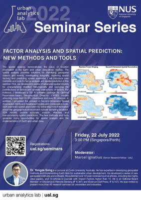
2022-07-22 — Factor Analysis and Spatial Prediction: New Methods and Tools
By Yongze Song, School of Design and the Built Environment, Curtin University, Australia
The spatial analysis demonstrates the value of location information in the Earth and urban data-driven studies. The spatial analysis provides solutions for identifying geospatial objects and events, investigating inequality, exploring spatial factors, and predicting spatial scenarios. I will introduce new methods and tools for factor analysis and spatial prediction in this seminar. First, we developed a series of advanced spatial models for characterising stratified heterogeneity and exploring the contributions of factors and spatially interactions of factors. For instance, I developed a GD R software package for Optimal Parameters-based Geographical Detector (OPGD) models attracting more than 30,000 downloads and over 60 citations. In addition, I proposed the concept of Second-Dimension Spatial Association (SDA) and developed models and computation tools. SDA examines spatial association by extracting more information about the geographical environment outside sampling locations. SDA models provide accurate, smooth, effective, and low-uncertainty spatial predictions. The new methods and tools generate more opportunities for spatial analysis and the implementation of Earth and urban data.
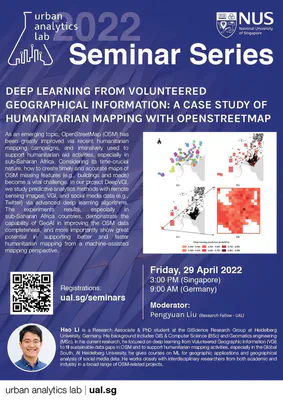
2022-04-29 — Deep learning from Volunteered Geographical Information: a case study of humanitarian mapping with OpenStreetMap
By Hao Li, GIScience Research Group, Heidelberg University, Germany
As an emerging topic, OpenStreetMap (OSM) has been greatly improved via recent humanitarian mapping campaigns, and intensively used to support humanitarian aid activities, especially in sub-Saharan Africa. Considering its time-crucial nature, how to create timely and accurate maps of OSM missing features (e.g., buildings and roads) become a vital challenge. In our project DeepVGI, we study predictive analytics methods with remote sensing images, VGI, and social media data (e.g., Twitter) via advanced deep learning algorithms. The experiments results, especially in sub-Saharan Africa countries, demonstrate the capability of GeoAI in improving the OSM data completeness, and more importantly show great potential in supporting better and faster humanitarian mapping from a machine-assisted mapping perspective.
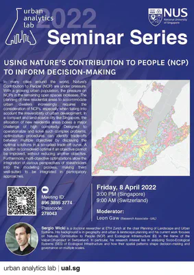
2022-04-08 — Using nature’s contribution to people (NCP) to inform decision-making
By Sergio Wicki, Planning of Landscape and Urban Systems, ETH Zurich, Switzerland
In many cities around the world. Nature’s Contribution to People (NCP) are under pressure. With a growing urban population, the pressure on NCPs in the remaining open spaces increases. The planning of new residential areas to accommodate urban dwellers increasingly requires the consideration of NCPs, especially when taking into account the irreversibility of urban development. In a compact and land-scarce city like Singapore, the allocation of new residential areas poses a major challenge of high complexity. Designed to operationalize and solve such complex problems, optimization procedures can identify trade-offs between multiple objectives by displaying the optimal solutions in a so-called trade-off curve. A solution is considered optimal if an objective cannot be improved, without reducing another objectve. Furthermore, multi-objective optimizations allow the integration of various perspectives of stakeholders into the modeling process, making them well-suited to be integrated in participatory approaches.
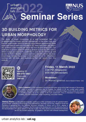
2022-03-11 — 3D building metrics for urban morphology
By Anna Labetski and Stelios Vitalis, 3D Geoinformation group, Delft University of Technology, the Netherlands
The study of urban morphology is a well established field for understanding the impact and the management of the urban form and the built environment which is useful in many different applications. While there have been a plethora of studies in 2D, there have been very little in 3D, of which a vast majority are not in fact true 3D and rather 2.5D. Our work aims to project urban morphology analysis to true 3D. This work is driven in large part due to the availability of open 3D city models as well as new 3D Python libraries. In our presentation we will examine 3D urban morphology metrics, the process of moving from 2D to 3D, difficulties in working with 3D data, and applications that can benefit from this analvsis.