about
our research group
principal investigator
people
our doctors
our seminars
news
publications
geospatial resources
our data+code
global streetscapes
zensvi
openfacades
specs
voxcity
sp-survey
global building morphology indicators
open data SG
join
openings
why us
application guide
student initiated projects
fellowships
contact
Events
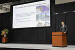
Keynote at the PLATEAU Symposium in Tokyo
Invitation by the Japan’s Ministry of Land, Infrastructure, Transport and Tourism.
Urban Analytics Lab
2025-02-18
2 min read
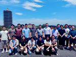
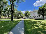
Visits to 15 universities in China
Guest lectures, discussions and exchanges at leading universities.
Urban Analytics Lab
2025-01-23
1 min read
Guest lectures at Peking University and Tsinghua University
Discussions and exchanges at leading universities in China.
Urban Analytics Lab
2024-06-22
1 min read
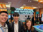
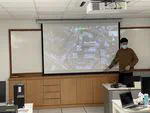
FOSS4G Asia and research visits in Seoul
Urban Thinkers Campus workshop session and visiting Chung-Ang University.
Urban Analytics Lab
2023-12-22
1 min read
AGU 2023 and research visits in the United States
Contribution to the main conference of The American Geophysical Union (AGU) and visits to four universities.
Urban Analytics Lab
2023-12-16
2 min read
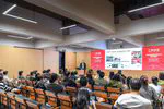
Recent talks by our researchers in international events
Our junior scientists in the spotlight.
Urban Analytics Lab
2023-10-06
1 min read
AAG 2023 and visits in the United States
Contribution to the main conference of The American Association of Geographers (AAG) and visits to two universities.
Urban Analytics Lab
2023-04-02
2 min read
State of the Map 2022
We are contributing to OpenStreetMap’s flagship conference.
Urban Analytics Lab
2022-08-18
1 min read
Urban Analytics Lab on tour in the United States
The PI of the Lab gave talks at MIT, Harvard, Stanford, and 6 other universities.
Urban Analytics Lab
2022-07-21
1 min read
Recent activities of the UAL: guest lectures and lab seminars
Guest lectures with Urban Redevelopment Authority (URA) and Grab
Urban Analytics Lab
2021-04-03
2 min read
»
Cite
×