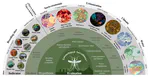
about
our research group
principal investigator
people
our doctors
our seminars
news
publications
geospatial resources
our data+code
global streetscapes
zensvi
openfacades
specs
voxcity
sp-survey
global building morphology indicators
open data SG
join
openings
why us
application guide
student initiated projects
fellowships
contact
Street View Imagery
VoxCity: a one-stop Python package for open geospatial data integration, 3D city model generation, and urban environment simulation
Our new open project, together with a paper published in Computers, Environment and Urban Systems.
Urban Analytics Lab
2025-11-17
3 min read
OpenFACADES: An open framework for architectural caption and attribute data enrichment via street view imagery
Our new open project, together with a paper published in the ISPRS Journal of Photogrammetry and Remote Sensing.
Urban Analytics Lab
2025-11-02
3 min read
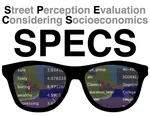
Introducing SPECS and its paper in Nature Cities
Our new open dataset Street Perception Evaluation Considering Socioeconomics (a massive global visual perception survey) and its analysis.
Urban Analytics Lab
2025-10-31
2 min read
Paper in Nature Sustainability
Revealing building operating carbon dynamics for multiple cities.
Urban Analytics Lab
2025-09-10
2 min read
Introducing SP-Survey, an open-source platform for streetscape perception research
The Streetscape Perception Survey Platform.
Urban Analytics Lab
2025-09-09
1 min read
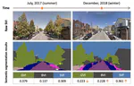
New paper: Quantifying seasonal bias in street view imagery for urban form assessment
Computers, Environment and Urban Systems publishes our collaborative paper that proposes a systematic analytical framework to characterise and evaluate seasonal bias using street-level images from 40 cities worldwide.
Urban Analytics Lab
2025-05-10
3 min read
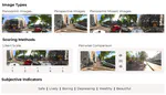
New paper: Designing effective image-based surveys for urban visual perception
Landscape and Urban Planning publishes our work on establishing visual perception survey design guidelines supported by statistics and experiments.
Urban Analytics Lab
2025-04-18
2 min read
New paper: Urban Aedes aegypti suitability indicators
The Lancet Planetary Health publishes our collaborative paper that presents a method using emerging big geospatial data to locate common mosquito breeding habitats in Rio de Janeiro.
Urban Analytics Lab
2025-04-17
3 min read
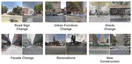
New paper: Physical urban change and its socio-environmental impact
Computers, Environment and Urban Systems publishes our collaborative paper that presents a method on mapping physical urban changes from street view imagery and understanding their socio-environmental impact.
Urban Analytics Lab
2025-04-01
2 min read
Introducing ZenSVI
An open-source software to facilitate the entire process of street view imagery analytics and supporting a wide range of use cases. Together with a paper in CEUS.
Urban Analytics Lab
2025-03-23
3 min read
»
Cite
×